Showing posts with label gtp. Show all posts

Tuesday, September 09, 2014

Knox and Forrest

Recently Darren Mckay posted (on the RailsMBSK Facebook group) an aerial photo (that I believe he took) of the Viterra grain elevator at Knox, just north of Brandon, Manitoba. With his permission I am posting it here... slightly edited for contrast and saturation.
Knox grain elevator, by Darren Mckay

We had a good discussion about the area and I thought I'd write a blog post about it. You see, if you look just a bit farther afield, there is a fair bit of rail history here. Here's a Google Earth screen capture that I annotated to show what was around here.

There's the CN Rivers subdivision (originally the Grand Trunk Pacific) going across the bottom, but you'll notice I marked in two CP subdivisions that do not exist any more: the CP Rapid City subdivision that ran between Brandon and Minnedosa, and the CP Lenore subdivision that ran between Forrest and Lenore, MB.

CP Rapid City
Let's talk about the CP Rapid City subdivision (don't confuse it with the CN Rapid City subdivision!)

As I said, the original CP Rapid City subdivision ran from Brandon to Minnedosa, running generally north-south with a big side trip to Gauthier and Rapid City.

View CP Rapid City Subdivision in a larger map
Map courtesy of Brian Switzer.

In 1963 the north portion was abandoned and the remainder was merged with the CP Miniota subdivision... which was abandoned in 1980.

Anyway, back to the area in question. In the Google Earth image I showed, there are two interesting areas. Forrest, Manitoba has a former Manitoba Pool grain elevator.
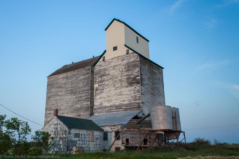
It was also the start of the CP Lenore subdivision. The wye that started the subdivision was just north of the elevator and is still visible from a satellite view (GPS: 49.971967, -99.941320). From the Forrest elevator, the rail corridor is still pretty visible.

If you kept going north on the CP Rapid City subdivision, you'd cross the CN Rivers subdivision. What is also evident from a satellite view is that there was a connecting track between CN and CP. (GPS: 49.998370, -99.946814)

I'm told that CP used this connecting track to serve the North Brandon passenger station. Oddly I can't find any reference to a CP North Brandon station in their timetables.

I found this image of the Grand Trunk Pacific station at Knox, dated somewhere between 1900 and 1909 (courtesy University of Saskatchewan Archives)

Knox was one of the Grand Trunk Pacific's alphabet railway stations. You may remember I recently posted about Justice, just up the line, and before that Gregg and Harte.
A little quiz for the reader: why did the mileage change between the Grand Trunk Pacific timetable and the CNR timetable?

CP Varcoe Subdivision
Continuing a few miles north on the CP Rapid City subdivision, you would encounter the start of the CP Varcoe subdivision, which ran from Varcoe to MacGregor and included the Brookdale and Oberon grain elevators.
It was another wye. (GPS: 50.070547, -99.964051)

That line crossed the CN Rivers subdivision (at the east end) as well as the old CN Neepawa subdivision.

...

Do you ever get the feeling that railways in the Prairies were like a big bowl of spaghetti, like some 1960s Model Railroader track plan?
All Railways Lead to Winnipeg
(courtesy Atlas of Canada, 1957)

Wednesday, November 24, 2010

Transcona Trains

CN often stops their long-distance trains in their Transcona yard in Winnipeg. These trains are bypassing Symington Yard and are merely stopping for new crew, refueling, or both.

The yard is located east of Beach Junction (the top entrance to Symington Yard) and west of Dugald, the first siding east of Winnipeg. The yard is also home to the sprawling (and mostly unused) Transcona Shops. There was an announcement back in 2003 that CN was building 100 boxcars at the Shops. I don't know what activities still take place at the shops. I believe they do rolling stock repair and I know there is always a lot of MOW equipment around.
CN Transcona Yard
Transcona is a convenient place to park trains because the main line and siding is about 10,000' between crossings, so there is enough room for most trains to stop here.

Often you can shoot the power for an eastbound train from Ravenhurst Street with a telephoto lens. I shot IC 2704 and BCOL 4626 from there on November 18.
IC 2704 in Winnipeg

I shot this train back in October. I still love the lighting in this picture.


Shots are also possible from Dugald but you have to contend with the pole line there.

The shops were built by the Grand Trunk Pacific as part of their transcontinental railway effort, and became part of the Canadian National Railways when the GTP went under. More information about Transcona here. Of course, there is also the Transcona Museum that I should visit at some point.

TRIVIA: Did you know Transcona is named for the TRANS-continental railway, and Lord StrathCONA?

ASIDE: Back to November 18, when I was going south on Plessis Drive I saw headlights on the GWWD track to the west. I stopped and waited, and it turned out to be a GWWD maintenance truck on the rails.
GWWD truck

Friday, December 14, 2007

The Bridges of Victoria County

CN 149 crossing the Salmon River trestle near Grand Falls, NB
I was recently asked to provide some information on the Salmon River area, and especially the Little River trestle near the giant Salmon River trestle. I've done some digging and I'll share some random notes with you.

The Salmon River bridge
The National Transcontinental Railway (NTR) was built in the 1910s for a variety of reasons, none of which seem good from a vantage point of almost one hundred years later. Its construction was authorized as part of an agreement between the federal government and the Grand Trunk Pacific (GTP) on July 29, 1903 where the government would built a railway from Moncton, NB to Winnipeg, MB, while the GTP would build from Winnipeg to Prince Rupert, BC. The GTP would then lease the NTR from the government for 50 years, paying 3% of construction costs per year for 43 years, after getting the first 7 years rent-free.

The problem was this. There was already a transcontinental railway - the Canadian Pacific Railway. Some people felt that the CPR needed some competition, so in a bizarre move the government authorized two additional transcontinental railways, the GTP and the Canadian Northern Railway. In the end, both of those failed and eventually became Canadian National Railways.

Back to the NTR. As was noted in the "Report of the National Transcontinental Railway Investigating Committee" in 1914, noone on the 4-person Commission appointed to oversee the NTR's contruction "had any experience or knowledge of railway building or operation" until 1911 when Major R.W. Leonard was added. The NTR was built to very high standards, including a prohibition against grades greater than 0.4% in the east, and the use of steel bridges only. It was estimated that the total cost of the NTR would be $161,300,000 in 1914 dollars. Conservatively, that's about 3 billion dollars in 2006 (source).
The Salmon River bridge under construction, 1910
OK, now back to the Salmon River trestle and its little sisters. The Salmon River trestle was built to span the Little Salmon River, and if you've ever seen the bridge you can see it is not a mighty river by any means. The bridge, however, is. Some statistics:
- completed: 1910 (see below)
- length: 3920 feet
- height: 195 feet
- cost: $815,070.87 (including sub- and superstructure)
- steel: 13,991,310 lbs. (just under 7000 tons)
- spans: 51

This is the second longest bridge of its type in Canada. The longest is in Lethbridge, Alberta.

Here is the Salmon River trestle on Google Maps, in the middle of the map.
Salmon River bridge, New Brunswick

There are three other trestles in the neighbourhood, none of which are small.
- Little River: 1242 feet
- Caton Brook: 1060 feet
- Graham Brook: 520 feet

I am trying to find out when the Little River trestle was completed. It appears to have been done by the end of 1910. Shirley E. Woods' great book Cinders and Saltwater states that "by the end of 1910 the road was finished and most of the track had been laid. On November 24, 1911, the 231-mile stretch from Moncton to Edmundston was opened for traffic."

Today the Salmon River trestle and its little sisters are on the Napadogan Subdivision of CN's eastern mainline, and sees six mainline freights and one or two locals each day. The photo below shows CN 305 crossing in August 2007.
CN 305 on the Salmon River trestle

See also: