Showing posts with label map. Show all posts

Tuesday, May 31, 2016

Finishing the Job: Part 5 - To Sunset and Beyond

This is part 5 of a series photographing grain elevators in Manitoba (part 1, part 2, part 3, part 4, summary).

Leaving Rivers, I headed toward the former CP Lenore subdivision. This subdivision was one of those prairie branch lines that didn't make a lot of sense, being parallel to the CP Carberry subdivision and the CP Miniota subdivision, never mind the nearby CN lines.
1926 CP Western Lines map
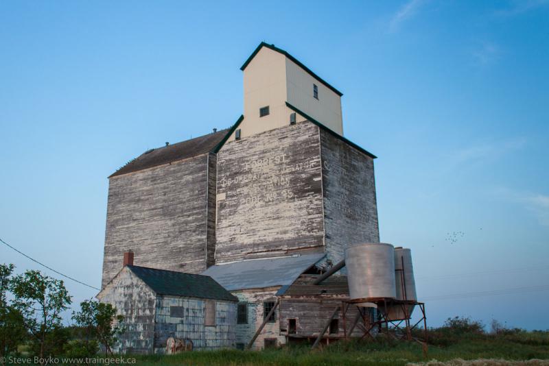
The Lenore sub was shortened in 1977 and was abandoned soon afterward. I wrote about the start of the Lenore sub at Forrest here.

I made my way to...

Bradwardine

Bradwardine's bins
The grain elevator in Bradwardine is still in use, despite not having rail access for the past 25 years. I could hear machinery working and in fact there was a truck in the elevator's driveway. Numerous bins stand on the other side of the former railway right-of-way.

You can see from the photo above and the distance shot below that various parts of the elevator have been replaced with metal siding.
Bradwardine from a distance
I didn't linger too long, and I didn't want to approach too closely since it was clearly still in use. I moved on toward Lenore, the end of the former subdivision.

Lenore

Lenore
The elevator at Lenore looks a lot like the Bradwardine one, except that it has a horizontal annex rather than a vertical one. Lenore was Manitoba Pool #40.

I'm not sure if Lenore is still in use or not - this Flickr photo seems to indicate that it is - there is a fence around the "track" side of the elevator that is clearly meant to discourage people from wandering over there. My photos are from the road side.

You can see that the driveway has been rebuilt with modern siding but the rest of the elevator and annex appears to be original.

I was able to walk up to the original railway right-of-way and take the below photo without crossing any fences.
Lenore and the former Lenore subdivision
The town of Lenore is a little larger than most of these small Prairie towns, and it has this cool sign:
Gulf sign, Lenore
No gas station, though!

While shooting the elevator, I was distracted by a tree full of birds.


Now I really had to do some criss-crossing to get the remainder of the elevators.

First I had to drive down to near Virden to get the Harmsworth elevator. En route I passed right by the Virden-Hargrave elevator.

Virden-Hargrave

Virden Hargrave
This elevator was not actually new to me, as I had photographed it last summer during a trip to Saskatchewan. However, I was here, so... grab a photo and carry on.

Before you ask, I have only a faint idea why it says Virden Hargrave on the side. It's clearly an ex Manitoba Pool elevator, but it's not in Virden nor in Hargrave. I guess it's near both of those.

It's adjacent to the CP Rocanville subdivision but it has no rail service.

I carried on to...


Harmsworth

The Harmsworth grain elevator
The grain elevator "in" Harmsworth is amongst the oldest remaining elevators in Manitoba. I'm pretty sure the Elva Lake of the Woods elevator is older but this one is not much newer.

Despite its appearance, this elevator is still in use. I met the owner of the elevator while I was photographing it, and he told me that there was some grain stored in it. He's quite concerned about vandalism and said that it has been vandalized twice recently. As a result, he keeps a close eye on the elevator. We had a good chat, but alas, I had to carry on before the sun set.

This elevator is also adjacent to the CP Rocanville subdivision but obviously has no rail service.


From Harmsworth it was another long drive up to the CN Rivers subdivision again, this time at Quadra.

Quadra

The Quadra grain elevator
The elevator at Quadra is privately owned and apparently still in use. It is a former Viterra concrete elevator with a capacity of 5,450 tonnes.

There are two tracks off the CN Rivers subdivision. The elevator was (is?) listed in CN's Producer Car Loader Station List with 7 car spots.

There is a lovely bend in the track between Quadra and nearby Arrow River that a few people have photographed trains at. I hung around for a bit but there was no sign of any train nor any green signals to be seen.

Here's Bill Hooper's photo at Quadra from 2003 that includes the older Manitoba Pool elevator. I think the current elevator is behind the wooden one.
QuadraMB 8-2-03 ScannedSlide

I went over to Arrow River and looked down the track there, too. Nothing but some sagging but picturesque telegraph wire.

On to Cromer in the falling dark!

I had to hop on the Trans-Canada Highway again for a few minutes, then headed down route 256. On the way I took a few sunset photos. You can tell I was getting into oil country!


Cromer

Cromer at last light
Cromer was the last elevator on my list. I knew from the start that I would get to Cromer after the sun set, so I was prepared to set up the tripod and take some long exposure photos. I like the results so much that I am sorely tempted to revisit some elevators after dark!

Blue Hour at Cromer
Cromer is smack dab in oil / fracking territory, and in fact I drove through a large terminal operated by Tundra. This large terminal is capable of handling 60,000 barrels per day and is serviced by CN via the CN Cromer subdivision (surprise!) The new rail facility is several kilometres east of the elevator and has two loading tracks and a couple of storage tracks, as far as I can see from Google Maps. Cando has the contract to switch this facility and has two locomotives there.

After Cromer, there was nothing left to do but head home. I'll wrap it up in the next post. Thanks for reading along!

Read on!

Friday, February 19, 2016

Tracing the Lines

Brian Gilhuly has published a free eBook featuring Eastern Ontario railway history (with maps!). You can view it on the Arnprior and McNab/Braeside Archives site at this link (PDF):

http://adarchives.org/Gilhuly/Tracing%20the%20Lines.pdf

The book features a lot of text and maps discussing the history of railways in Eastern Ontario, from the Bytown and Prescott Railway in 1854 to today's CN / CP / VIA / QGRY lines. The latter part of the book features a series of maps showing the evolution of trackage (and communities) from the beginning of railways in eastern Ontario to today. It's been updated recently to include VIA's acquisition of the CP Brockville subdivision.

Check it out!


Tuesday, September 09, 2014

Knox and Forrest

Recently Darren Mckay posted (on the RailsMBSK Facebook group) an aerial photo (that I believe he took) of the Viterra grain elevator at Knox, just north of Brandon, Manitoba. With his permission I am posting it here... slightly edited for contrast and saturation.
Knox grain elevator, by Darren Mckay

We had a good discussion about the area and I thought I'd write a blog post about it. You see, if you look just a bit farther afield, there is a fair bit of rail history here. Here's a Google Earth screen capture that I annotated to show what was around here.

There's the CN Rivers subdivision (originally the Grand Trunk Pacific) going across the bottom, but you'll notice I marked in two CP subdivisions that do not exist any more: the CP Rapid City subdivision that ran between Brandon and Minnedosa, and the CP Lenore subdivision that ran between Forrest and Lenore, MB.

CP Rapid City
Let's talk about the CP Rapid City subdivision (don't confuse it with the CN Rapid City subdivision!)

As I said, the original CP Rapid City subdivision ran from Brandon to Minnedosa, running generally north-south with a big side trip to Gauthier and Rapid City.

View CP Rapid City Subdivision in a larger map
Map courtesy of Brian Switzer.

In 1963 the north portion was abandoned and the remainder was merged with the CP Miniota subdivision... which was abandoned in 1980.

Anyway, back to the area in question. In the Google Earth image I showed, there are two interesting areas. Forrest, Manitoba has a former Manitoba Pool grain elevator.

It was also the start of the CP Lenore subdivision. The wye that started the subdivision was just north of the elevator and is still visible from a satellite view (GPS: 49.971967, -99.941320). From the Forrest elevator, the rail corridor is still pretty visible.

If you kept going north on the CP Rapid City subdivision, you'd cross the CN Rivers subdivision. What is also evident from a satellite view is that there was a connecting track between CN and CP. (GPS: 49.998370, -99.946814)

I'm told that CP used this connecting track to serve the North Brandon passenger station. Oddly I can't find any reference to a CP North Brandon station in their timetables.

I found this image of the Grand Trunk Pacific station at Knox, dated somewhere between 1900 and 1909 (courtesy University of Saskatchewan Archives)

Knox was one of the Grand Trunk Pacific's alphabet railway stations. You may remember I recently posted about Justice, just up the line, and before that Gregg and Harte.
A little quiz for the reader: why did the mileage change between the Grand Trunk Pacific timetable and the CNR timetable?

CP Varcoe Subdivision
Continuing a few miles north on the CP Rapid City subdivision, you would encounter the start of the CP Varcoe subdivision, which ran from Varcoe to MacGregor and included the Brookdale and Oberon grain elevators.
It was another wye. (GPS: 50.070547, -99.964051)

That line crossed the CN Rivers subdivision (at the east end) as well as the old CN Neepawa subdivision.

...

Do you ever get the feeling that railways in the Prairies were like a big bowl of spaghetti, like some 1960s Model Railroader track plan?
All Railways Lead to Winnipeg
(courtesy Atlas of Canada, 1957)

Tuesday, January 28, 2014

What About the Ocean?

VIA 6416 at McGivney
VIA 15 detouring through McGivney in July 2005
In the wake of the recent announcement on the fate of the CN Newcastle subdivision, many are asking what would become of the VIA Rail Ocean if the Miramichi-Bathurst section was abandoned. Well, there are three choices, one of which is highly unlikely.

Follow the Atlantic
It's possible that VIA could choose the route of the former Atlantic, running from Halifax and Moncton to Saint John and then through Maine to Sherbrooke and on to Montreal. This is highly unlikely for several reasons, including the customs clearing issues, traveling over two different shortlines (NB Southern and whatever Fortress appoints to run the former MMA), and the fact that I don't think through traffic through Lac-Mégantic has even resumed yet. I believe we can safely dismiss this option.

Through the Wilds
The most obvious choice is to run through central New Brunswick over the CN Napadogan subdivision and into Quebec over the CN Pelletier subdivision, rejoining the current Ocean route at St. Andre Junction. This is CN's main line through the Maritimes and is well maintained... despite a couple of recent derailments.

Here's a map I drew showing that route. Click on the map for an interactive version.

1977 Ocean Detour Schedule
The Ocean has detoured on this route before. Back in 1977 the Ocean was routed here for about six months due to a landslide on the northern route - the amended schedule is shown to the right. In better days a decade earlier, there was an RDC (Rail Diesel Car) that ran between Moncton and Edmundston. Heck, for a short time in the summer of 1967, the Cabot ran between Montreal and Sydney via Edmundston, and from October 29, 1967 to January 7, 1970 the Ocean ran via Edmundston while the Scotian continued on the northern route. This route would be similar today but since the Pelletier cutoff was built, the train would not go through Monk and Ste. Claire.

There are a few downsides to having the Ocean run over the Napadogan.
  • Northern New Brunswick and northern Quebec would lose their passenger service. There is an alternative, Maritime Bus in NB and Orléans Express in Quebec, although I think you'd find most people would rather take the train.
  • There are fewer available passengers over the Napadogan route, given that the Napadogan runs through virtual wilderness between Moncton and Edmundston. This would be a gain for Edmundston, Grand Falls and a few other communities, but fewer passengers = less revenue = more chance of outright cancellation.
  • A capital investment would be required for VIA to provide station facilities, as nothing really exists since passenger service ceased in this area.
One upside might be that Fredericton could get indirect passenger service via a connection at McGivney.. maybe.

Give It Up
The most serious possibility is that VIA Rail will simply stop running the Ocean altogether. The chilling headline Via Rail's Maritime-Quebec passenger service in doubt says it all.

A spokesperson for VIA Rail, Mylène Bélanger, was quoted as saying: "At this time it's still a hypothetical question, but if this section is abandoned we'll look into the commercial viability of all other alternatives, for connecting between Halifax and Montreal, before adopting any other route." (emphasis mine)

As for purchasing the section of track between Bathurst and Miramichi, Bélanger said, "Via Rail does not have the financial resources to acquire or maintain this section of the tracks. So we'll wait for any developments."

But What About The Gaspé?
One more thing - don't forget that the train serving the Gaspé peninsula (the former Chaleur) ran as part of the Ocean between Montreal and Matapedia. If the Ocean was to run a different route, or be cancelled altogether, the economics of the Gaspé train would be even worse as it would have to bear the entire cost of the Montreal-Matapedia section.

You may recall that the Gaspé train has not been running for quite some time, due to track problems. These track problems have been solved between Matapedia and New Carlisle, yet VIA has not committed to returning to the route.

The future of passenger rail east of Montreal is more and more in doubt.

EDIT: Thanks to Tom Box for a few corrections.

Thursday, October 06, 2011

Winnipeg Train Photos

Winnipeg Train Sightings

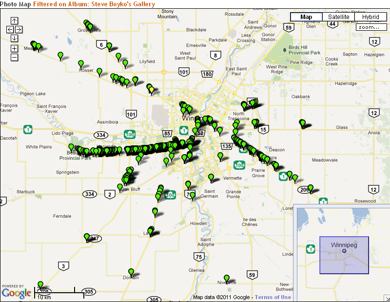
I've sure taken a lot of photos in the Winnipeg area, haven't I? A quick search of my photo gallery shows 604 matches for "Winnipeg"!

You can see that I like to take photos on the CN Rivers subdivision (the long horizontal line of pushpins under highway 1) and a fair number on the CN Sprague subdivision (diagonally down on the right side of the map along highway 1).

Click on the map to see where in the world I've taken photos!

Wednesday, June 09, 2010

Where I've Taken Photos

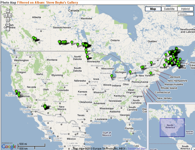
Where I've taken photos
I use the open-source Gallery program to manage my photos. I like it a lot. It is very flexible, easy to use and most importantly free.

One cool feature of Gallery is the ability to attach GPS coordinates to your photos, and then view them on a map. You do this by going to my gallery, and maybe going into a section like NBEC Photos or deeper, then clicking on the "View Album on a Map" link on the left side. You can also view an album in Google Earth.

It uses Google Map technology, so you can pan around, zoom in, etc. Clicking on the green marker shows a thumbnail of the photo, and you can then click on that to go to the full photo view.

I've been going back and adding locations to my photos. There are a lot left to be done, but I'll keep picking away at it. All new photos I put in have GPS coordinates built in, thankfully.

I hope you like this feature! See where I've taken pictures.

Friday, September 25, 2009

New Brunswick Railway Heritage Association Site Launched

New Brunswick Railway Heritage Society | French version

I am pleased to finally write about a project I have been involved in for several years. A few years ago, people from several railway-oriented attractions in New Brunswick got together to discuss how to better market the sites. The idea that arose from those meetings was to feature several "trails" linking sites together in a trail that could be visited in one or two days. A lot of work went into the preparation of these trails, and a web site was developed and has now been launched.

The site centers on an interactive map of the province, showing the trails and the many railway attractions in New Brunswick. The visitor is invited to click on the trails and attractions to learn more about them, and then move on to the individual attraction's web site, if available.

I have not been involved in the project since I moved out west, but before that I helped out setting up the basic web site and participating in the many meetings. It was a real team effort from the many railway attractions in New Brunswick. I am pleased at how well everyone worked together. I think it is important to acknowledge the great help provided by the Heritage Branch of the New Brunswick Wellness, Culture & Sports Department and the New Brunswick Tourism and Parks Department. The site bills it as a project of the Canadian Railroad Historical Association, and it is, but it involves many more players.

A couple of my photos are on the site, including the Salmon River trestle photo at the bottom of each page featuring CN train 149 on August 12, 2007

There is a Daily Gleaner article about it, featuring my good friend Art Clowes, one of the premiere railway historians in the province.

I invite you to visit the site and have a look!

Saturday, August 04, 2007

New Brunswick and Canada Railway

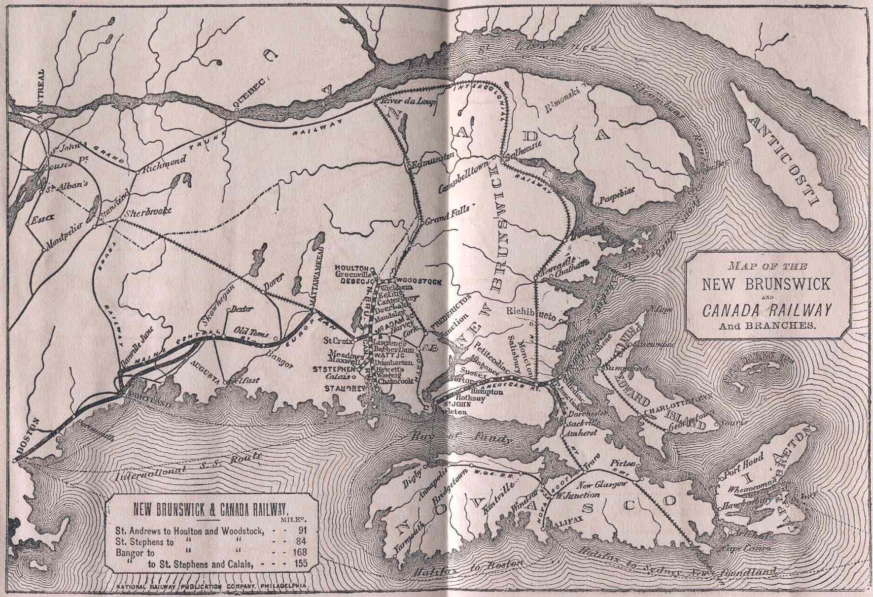
I recently won the "Manager's Report For the Year 1871" for the New Brunswick and Canada Railway on eBay. The NB&C was the successor to the St. Andrews & Canada Railway after it went bankrupt. Someday I will type the text of the report in for your reference but today I will just share the map.


In 1871 not all of the railways pictured on the map were actually in operation. I think the solid lines indicate railways in operation and the hatched lines are areas under construction.

The European & North American was complete, but just barely, with the last spike of the Western Extension between Saint John and Maine being driven on October 19, 1871 with U.S. President Ulysses S. Grant present. McAdam was already becoming important, as the junction between the NB&C and the E&NA.

The Intercolonial was under construction but not in operation at this time, except for a few sections acquired from other railways such as the E&NA and the Nova Scotia Railway.

The track between Woodstock and Fredericton was not laid until 1873, and it did not follow the arrow-straight line shown in this map.

I hope you like the map!